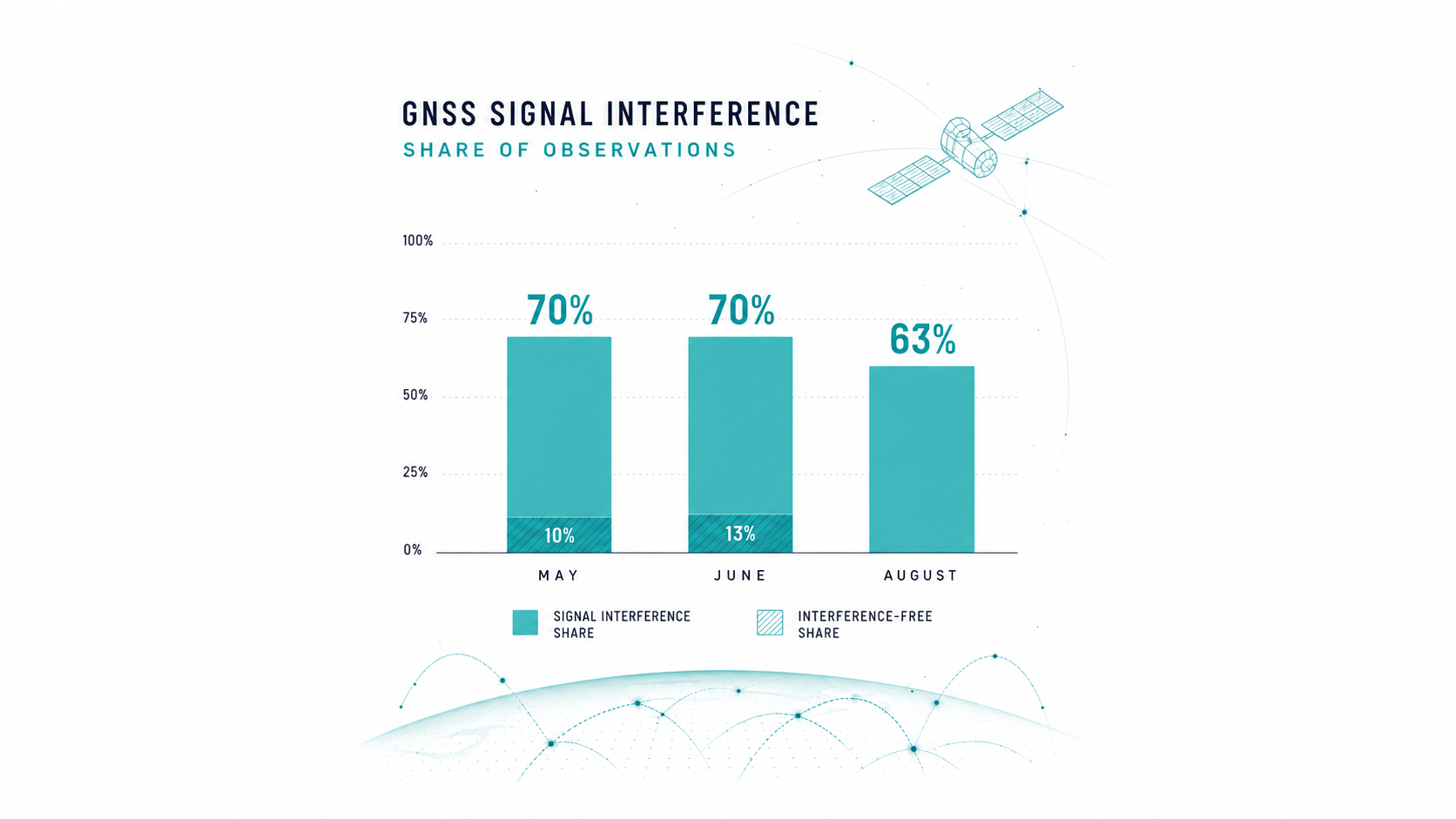
May and June 2026 each recorded significant multi-hour interference across all GNSS bands on 70 per cent of days at the Gdansk station; the first 19 days of August recorded 63 per cent. Across May to August the share runs between 39 and 70 per cent, which the institute describes as a permanent condition rather than an event. Space Insights.
Poland's National Institute of Telecommunications (Instytut Łączności — Państwowy Instytut Badawczy), a state research institute, has reported that during the first 19 days of August it recorded significant interference across all GNSS frequency bands on 63 per cent of days at its monitoring station in Gdańsk. The published analysis covers the Tri-City area of Gdańsk, Gdynia and Sopot on the country's northern coast.
The disruption it describes ranges from partial interference in a single frequency band to multi-hour interference across all bands at once.
The comparison is the point
Read alone, 63 per cent of days sounds like a deterioration on what came before. The institute's own monthly figures for the early summer are higher. May and June 2026 each recorded significant multi-hour disruption across all bands on 70 per cent of days, with only 10 per cent of days in May and 13 per cent in June completely free of interference.
August is therefore not an escalation on the early summer. It is persistence at a slightly lower level, measured at the same station by the same body, and the institute puts the May to August share of days with significant interference across all bands between 39 and 70 per cent. Partial interference in a single selected band runs lower over the same summer months, between 17 and 29 per cent.
The institute frames the series as a standing condition rather than an event. It records anomalies at the station since January 2024 and states that, given the external character of the phenomenon and defensive and operational electronic warfare activity in the Baltic basin, the situation is permanent in character: the anomalies will persist as long as activities requiring the emission of jamming signals are conducted in the region.
That distinction matters for anyone planning around it. A spike invites a response; a plateau invites a design assumption. What the Polish figures describe is the second thing: a sustained condition in which GNSS on that coast is unavailable or degraded on most days, and has been for months.
What the institute says and does not say
The institute characterises the interference as deliberate and associates it with electronic warfare activity in the Baltic Sea basin. It did not identify the source of the interference in its August analysis.
Polish authorities have previously attributed similar disruption in the Baltic region to Russia and, per European Spaceflight, submitted evidence to the International Civil Aviation Organization in July 2025. That is prior state action and is reportable as such. It is not the institute's finding in this analysis.
The consequence for operators
The practical reading is not about geopolitics. It is that a specific, published measurement now exists for a stretch of European coastline, produced by a national technical body rather than inferred from user reports.
The institute addressed its own guidance to everyday users, naming smartphones, shared city bikes and scooters, municipal fleets and drones. The professional reading is ours: for shipping, aviation, surveying, precision agriculture and any timing-dependent infrastructure operating in that area, GNSS should be treated as an intermittently unavailable service rather than a continuously available one, and the planning question is what the backup is on the days when it degrades. The institute's own guidance sits at the same level: do not rely on phone map applications alone in the affected area, expect city bike, scooter and municipal fleet location systems to fail on affected days, and treat drone flights as extremely risky because of sudden link loss and loss of position stabilisation. For satellite navigation providers, the more interesting fact is that a member state's technical institute is now publishing month-on-month interference rates, which makes the condition measurable rather than anecdotal.
Get briefings like this every Friday.
Subscribe